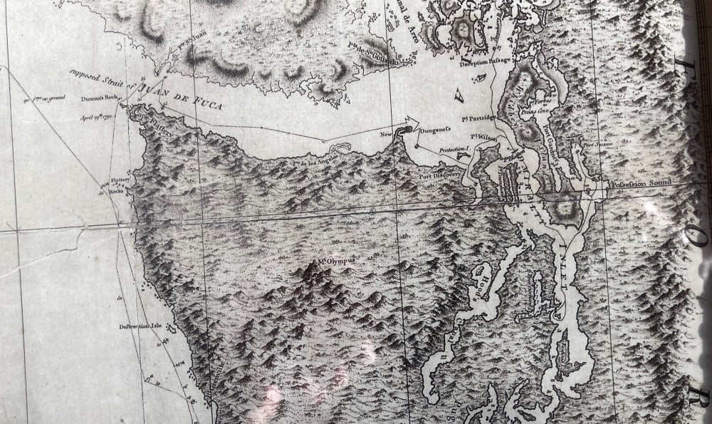
On a foggy spring morning in May, 1792, 231 years ago this week, a sea-weary group of British sailors made their way out of the Strait of Juan de Fuca, rounded the point and paused for an hour or so at what we now know as Port Townsend, waiting for the fog to lift.
When the sky cleared, George Vancouver, the crotchety English commander, was astounded by the view. “A very spacious inlet now presented itself,” he wrote in his journal, “and a very remarkable high round mountain, covered with snow.”
And with that, Vancouver and his crew set out to explore and map what became known as Puget Sound – one of the last uncharted coastlines on the globe.
To get here, he and 145 crew (some of them as young as 16) had sailed for a year, from England and around the Horn of Africa, across the Southern Ocean to Australia, Tahiti and Hawaii and finally to the Northwest Coast.
They spent a month charting Puget Sound, and two more years exploring the coastline to the Bering Sea. And then headed home, completing their circumnavigation in four years.
Vancouver was not a charismatic or heroic character. On the contrary, his journals suggest a dour, humorless commander whose disciplinary practices resembled those of the infamous Captain Bligh. This was no coincidence, since Vancouver and Bligh served together as midshipmen on Cook’s third voyage. Crewmen were lashed repeatedly, and one of them physically attacked him on a London street after his return. He probably had it coming.

As he mapped the coastline, he named iconic landmarks from Mount Rainier and Vashon Island to Port Townsend and Mount St. Helens after his Navy chums – bewigged and powdered nobles, many of whom fought against us in the War of Independence but never laid eyes on the Pacific Ocean, let alone the landmarks that bear their names.
He showed little patience for the scientific pursuits of fellow traveler Archibald Menzies, a brilliant naturalist and protégé of Joseph Banks. Menzies signed on as ship’s doctor but was driven by his botanical curiosity, roaming the beaches and forests, sketching and describing samples of a wondrous ecosystem.
Vancouver died at age 40, just three years after the voyage. And nobody noticed. When I set off in search of his gravesite outside London some years ago, I stepped into a bookshop to ask directions. “Oh yes,” the bookseller responded, “that Canadian chap?”
But the dying commander had just enough time to convert his ship’s journals into a multi-volume account of the four-year circumnavigation, focusing on three years of work on the Northwest Coast. The journals and accompanying charts were published, translated into French and German and guided at least two generations of Pacific voyagers.
Occasionally he waxed poetic – especially those first few weeks in Puget Sound. But the journals are mostly flatly prosaic, laden with intricate reports on his navigational coordinates.
Still, his are the most detailed European observations of this corner of the globe before development and technology took their toll.

And this Canadian chap was one heck of a cartographer. His mission was to explore and map the Northwest Coast from here to the Bering Sea, and he took the job seriously. To do this, he was equipped with a compass, sextant, telescopes for celestial sightings and a couple of John Harrison’s remarkable chronometers, intricate clocks used for determining longitude.
The resulting charts of the Northwest coast, and of parts of Australia and the South Pacific, are amazing. Occasionally I’ll check his recorded longitude-latitude coordinates against my GPS, and they’re astonishingly close. Some of his South Pacific charts were used by the Navy as recently as WWII – 150 years after they were drawn.
Thanks to anonymous collaborators, they are also stunning works of museum or gallery-worthy art, the creative blend of precision measurements and mathematics, later translated into pen and ink charts, then to copper engravings and finally to the printed page.
Two and a third centuries later, Vancouver’s legacy lies in those journals and charts.
They are available. The Hakluyt society published the authoritative and thoroughly annotated version of the journal in 1984, delivered by British Columbia historian W. Kaye Lamb. But that four-volume set is heavy, scarce and expensive.
More accessible is Edmond Meany’s “Vancouver’s Discovery of Puget Sound,” published in 1907 – a complete rendition of the journals (but not the charts) from 1792. Reprints are readily available online. But Meany’s original book was reprinted several times, and hardcover editions can be found for $30 to $50 in local bookshops or on Alibris.com.
Reproductions of those handsome charts can be found at reasonable prices on Ebay and other sites.

Ross, I was amazed by the accuracy of the chart illustrated. But you probably meant the Cape of Good Hope since the “Horn of Africa” is also known as the Somali Peninsula and that’s pretty much where it is.
Well, Dick…. At least I got the right continent. For an incontinent like me, that’s saying somepin. Onward and upward, but not until you round that cape. -r
Great story, Ross. At our age, we’re all occasionally incontinent. Have you read the Aubrey-Maturin series? Menzies sounds a bit like Maturin.
Great historical article, maybe as an aside, a good reason to rename the ‘mountain’, Mount Tahoma.
A well written, and very engaging summary of the voyage that brought such marvelous maps into being. Kudos.